New State Mapping Finds Breast Cancer in Unexpected Communities
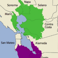
 (map: prepared by the California Breast Cancer Mapping Project)
A new way of mapping the incidence of breast cancer in California has turned up four “areas of concern” that did not previously exist.
A study by the California Breast Cancer Research Program of the University of California used census tract data rather than county-based information to give a more nuanced view of trouble spots. Counties are convenient ways to group data because many funding methods and interventions are executed as county-level initiatives, but have inherent limitations for analytical purposes.
An “area of concern,” which could be smaller than a county or stretch across county lines, is one in which breast cancer rates are 10-20% higher than the state average.
The “areas of concern” were: portions of Ventura and Los Angeles counties; the southern portion of Orange County abutting a small portion of Riverside County; a swath of territory from Marin County through the northern San Francisco Bay area; and southern San Francisco Bay communities in San Mateo County, northern Santa Clara and southern Alameda counties.
Breast cancer is the most common type of cancer found among California women. More than 26,000 new cases are diagnosed annually and account for 4,175 deaths.
The data used in the report was gleaned from the California Cancer Registry for years 2000-2008. It included census tracks of patient residences at the time of diagnosis. Data from the registry only becomes available two years after it is collected.
The study does not try to connect the incidence of breast cancer with a possible cause—genetic, environmental or otherwise—which is one of the reasons the report uses “area of concern,” rather than “cancer cluster” to describe a focal point. Cancer cluster has additional implications, including an environmental cause. An area of concern is described as “a collection of census tracts that together have elevated rates of invasive breast cancer that cannot be attributed to population growth, data limitations, or random chance.”
In fact, the study’s authors said the maps can’t be used to determine links between breast cancer rates and the environment because many scientists believe that cancer doesn’t develop until decades after exposure takes place. The study’s maps are based on where women live at the time they are diagnosed, not necessarily where they might have been exposed to pollutants.
–Ken Broder
To Learn More:
Elevated Rates of Invasive Breast Cancer in Bay Area Cities (by Leah Bartos, California Health Report)
Research by the Public Health Institute Identifies New Communities Within California with Elevated Breast Cancer Rates (Press release)
California Breast Cancer Mapping Project (Public Health Institute)
- Top Stories
- Controversies
- Where is the Money Going?
- California and the Nation
- Appointments and Resignations
- Unusual News
- Latest News
- California Forbids U.S. Immigration Agents from Pretending to be Police
- California Lawmakers Urged to Strip “Self-Dealing” Tax Board of Its Duties
- Big Oil’s Grip on California
- Santa Cruz Police See Homeland Security Betrayal in Use of Gang Roundup as Cover for Immigration Raid
- Oil Companies Face Deadline to Stop Polluting California Groundwater


