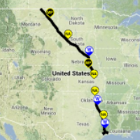
The Mysterious Route of the Keystone Pipeline
 (graphic: Keystone Mapping Project)
While the Obama administration decides whether to approve the controversial Keystone XL pipeline project, Americans have no way to find out exactly where more than a thousand miles of pipe would be laid.
That’s because neither the U.S. government nor the Canadian company pushing the pipeline will reveal the proposed route.
What is known is that the pipeline would travel about 1,700 miles while crossing six states: Montana, South Dakota, Nebraska, Kansas, Oklahoma, and Texas.
Thomas Bachand, creator of the Keystone Mapping Project, wanted to find a map of the proposed construction to show people on his website what areas might be impacted by the work. He tried the State Department and got nothing. He then tried TransCanada, the oil company that wants to ship tars sands oil through the pipeline. There, Bachand got “the runaround. Their excuse was that [releasing the information] was a national security risk, which is just a joke,” he told NPR in 2012.
The information blackout includes withholding which streams or rivers the pipeline would cross.
“Waterbody crossings are another key feature that is largely missing,” Bachand told DeSmogBlog.com. “If the pipeline crossed a mile upstream from one’s property, or neighborhood, or community park, or aquifer, most people would want to know about it.”
-Noel Brinkerhoff
To Learn More:
Obama State Dept. Leaving Citizens in the Dark About Exact Keystone XL Pipeline Route (by Steve Horn, DeSmogBlog.com)
The Keystone XL Map the State Department Doesn’t Want You to See (by Harry Stevens, Triple Pundit)
Keystone XL Map Complete 2D (Keystone Mapping Project)
- Top Stories
- Unusual News
- Where is the Money Going?
- Controversies
- U.S. and the World
- Appointments and Resignations
- Latest News
- Musk and Trump Fire Members of Congress
- Trump Calls for Violent Street Demonstrations Against Himself
- Trump Changes Name of Republican Party
- The 2024 Election By the Numbers
- Bashar al-Assad—The Fall of a Rabid AntiSemite


Comments