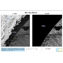
Spy Photos of Alaska Reveal Shrinking Ice Sheets
Monday, July 27, 2009
 Barrow: Ice in 2006 (left); no ice in 2007 (right)
The Bush administration’s refusal to acknowledge the danger of global warming included withholding from the public startling satellite images of disappearing ice packs off the coast of Alaska. The photos taken several years ago by orbiting satellites were released last week by the Department of the Interior as part of President Barack Obama’s plan to push Congress and the nation towards adopting new policies designed to stem the speed of global warming.
Among the approximately 1,000 satellite images released are those taken of the Alaskan port of Barrow. One photo from July 2006 shows sea ice still floating off the coast, while a second taken the following summer is completely void of any sea ice. Scientists estimate more than a million square kilometers of sea ice melted away within just one year.
-Noel Brinkerhoff
Revealed: The Secret Evidence of Global Warming Bush Tried to Hide (by Suzanne Goldenberg and Damian Carrington, The Observer)
U.S. Unveils Spy Images of Arctic Ice in Rare Move (by Deborah Zabarenko, Reuters)
Barrow Alaska - 71N, 156E (U.S. Geological Survey)
- Top Stories
- Unusual News
- Where is the Money Going?
- Controversies
- U.S. and the World
- Appointments and Resignations
- Latest News
- Trump to Stop Deportations If…
- Trump Denounces World Series
- What If China Invaded the United States?
- Donald Trump Has a Mental Health Problem and It Has a Name
- Trump Goes on Renaming Frenzy


Comments